
The 10 Best Hikes On Fogo Island, Newfoundland and Labrador
Published August 20th, 2024
Photography by Jennifer Bain

Great auk statue on Joe Batt's Point Trail
On Fogo Island, every trail tells a story. My favourite is about an extinct, flightless seabird called the great auk. A close second has a cheeky flat earth twist.
Would it surprise you to learn that this bucket list Newfoundland and Labrador destination is about 25 kilometres long, 14 kilometres wide and roughly quadruple the size of Manhattan? You will find much to do as you drive the art-infused island, but you should also walk along the coast and through bogs, barrens and forests, watching for caribou and silver foxes.
Nobody knows for sure what Portuguese explorers and fishers were thinking hundreds of years ago when they named this windswept island Fogo (the Portuguese word for fire is fuego). Some suspect it had to do with the once frequent forest fires and human-made signal fires.
What I do know is that in the seven years I’ve been unravelling the mysteries of my second home, I’ve been slowly getting to know its 2,200 people, 11 communities and 10 main hiking trails.


It used to freak me out that trails aren’t always well marked and it’s easy to get (briefly) lost. This summer — armed with a guidebook, rudimentary maps and descriptions that were full of conflicting details — I hiked Fogo’s top 10 trails over six days.
The shortest trail is really a 20-minute stroll. The longest clocks in around two-and-a-half hours. It takes me 15 minutes to briskly hike a kilometre, but longer if I stop to take photos or chat with strangers.
I’ve noted the distances recorded by my phone’s step-counting app. But consider these numbers starting points because Fogo’s trails don’t just tell stories — they send you off on delightful detours and encourage you to meander.
Joe Batt’s Point (Great Auk) Trail


Perched on seaside rocks, there is a haunting memorial to an extinct, flightless bird that stood about 2.5-feet tall and weighed five kilograms. The bronze statue of a great auk was erected in 2010 by American artist Todd McGrain as part of his Lost Bird Project. It looks towards both the Funk Island Ecological Reserve, an island where the penguin-like species once came to breed, and an island off Iceland where fishermen killed the last confirmed pair in 1844.
No trip to Fogo — a resilient outport community that has resisted government attempts to centralize the province’s population — is complete without taking time to ponder extinction and conservation.
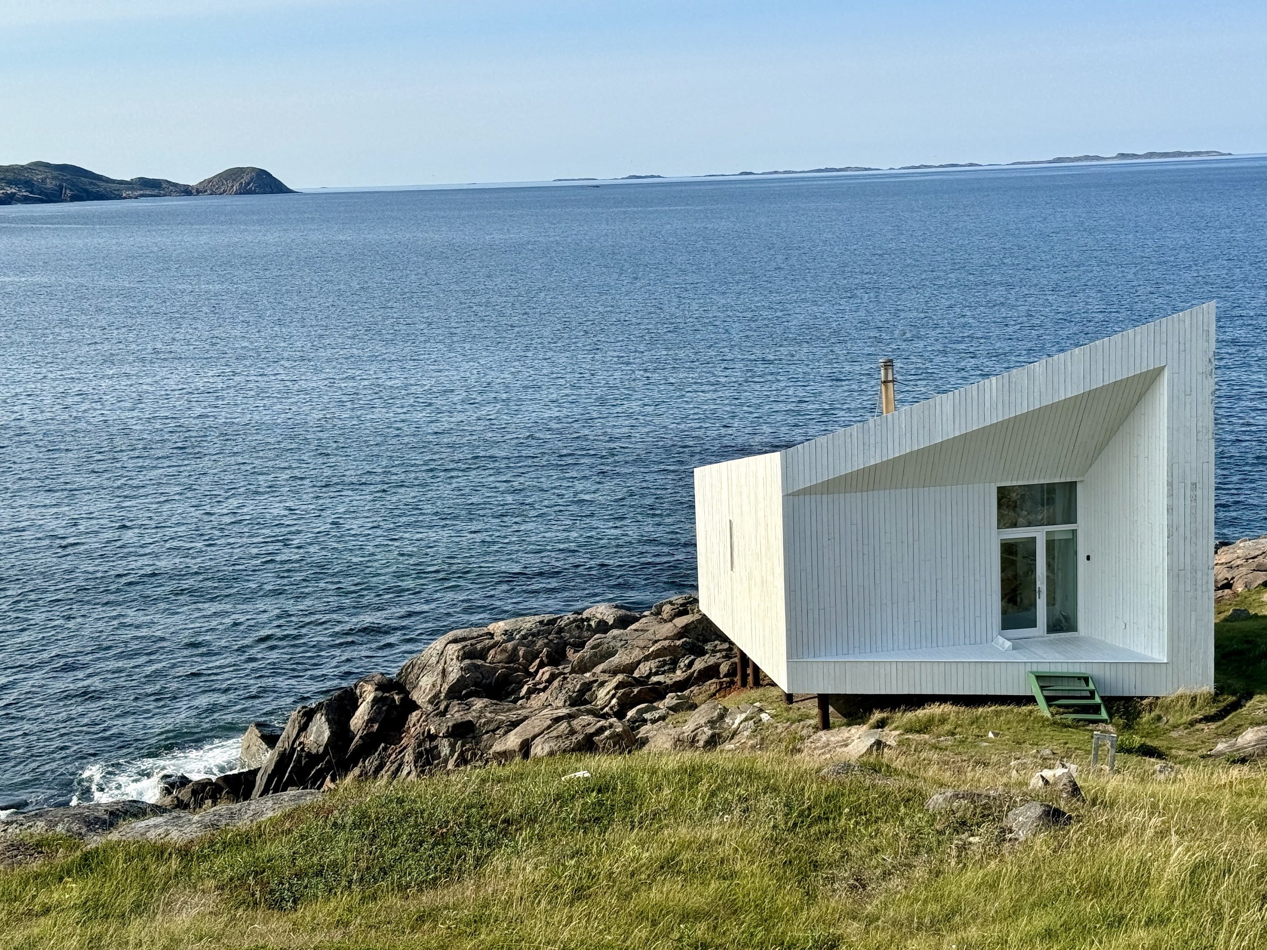
This well-marked trail hugs the coast and starts with views of the Fogo Island Inn and its sibling Long Studio. The largest of four studios designed by architect Todd Saunders was built for the Fogo Island Arts’ international residency program under the Shorefast social enterprise umbrella. You’ll pass community gardens, “gazes” (stone hunting blinds) and raised beaches that now lie above the water level because of geological changes since they formed.
Trail Type: Loop
Approximate Distance: 4 km
Trailhead: In Joe Batt’s Arm, park at Etheridge’s Point Community Park.
Insider Tip: Just before the auk statue, a steel sign points to Brook’s Point and shows the image of a lighthouse. This 2.5-kilometre round trip — on an overgrown footpath that’s challenging to follow — goes to a minor shore light (not a lighthouse) so consider it a detour for avid hikers only.
Brimstone Head Trail


As much as I love the Great Auk Trail, I know that if you only do one Fogo hike, it will be this one. It’s not just because it can be done in half an hour — after all it’s a challenging and often windy climb up and down wooden staircases. It’s because this rocky outcrop looms so large over this side of the island.
At the top of this striking mound of ancient volcanic rock, you’ll find a platform with 360-degree views. There’s a sign noting the distance to 10 spots around the world including Fort McMurray, Alberta (where many Newfoundlanders work in the oil sands) and Fogo, Cape Verde (a Portuguese island with a volcanic mountain).
This is where you’ll find the “Four Corners of the Flat Earth” sign that celebrates our Fogo, Hydra (Greece), the Bermuda Triangle and Papua New Guinea. It’s a claim that was reportedly started in the 1970s by New Brunswick university professors who were part of the now-defunct Flat Earth Society of Canada. It’s an irreverent claim that tourism folks continue to have fun with.
Trail Type: Out-and-back
Approximate Distance: 1.4 km (longer if you take the “Brimstone Head Via Scenic Route” option at the start, and the offshoot to Simms’s Beach on your return to see sun-bleached rocks that have been smoothed by pounding waves).
Trailhead: In the town of Fogo, park at the Brimstone Head RV Park operated by the Brimstone Head Lions Club.
Insider Tip: To capture a great shot of Brimstone Head on a clear day, turn right at the “Welcome to Fogo: Settled in Early 1700” sign on the way into town and take a short gravel road towards two cemeteries. Look for the footpath to a new wooden viewing platform.
Fogo Head Trail


There’s a steep and daunting wooden staircase on this trail and wise locals say do it so you walk down the stairs instead of up them. That means starting near Brimstone Head and ending at the Garrison Point Battery (and Dale Payne’s lovely shop The Lookout Quilts and Things).
In between, you’ll slowly climb rocky hills, cross bits of boardwalk, take ancient footpaths, rest at lookouts and linger above or on rocky shorelines. You’ll get fabulous views of Brimstone Head, Change Islands and Fogo town. Keep an eye on the ocean where you might spot icebergs in the spring, whales in the summer or maybe even some locals out fishing for cod.
Trail Type: Point-to-point
Approximate Distance: 2.9 km (plus another 1.3 km on paved roads through town to return to your vehicle unless you loop back the way you came).
Trailhead: In the town of Fogo, just before turning left to the Brimstone Head RV Park, park beside the small Fogo Head Trail sign.
Insider Tip: Sleeping Child Rock, an unmarked oddity a few minutes off the trail, is hard to find but worth the effort. At the foot of the tallest lookout, walk away from the ocean and along a gulch called Frenchman’s Well. Look back to sea and when you can line up Lighthouse Island and the distant yellow house on the point, you’ll hopefully be standing near this small boulder which looks ordinary on one side and like someone doing the child’s pose in yoga on the other.
Lion’s Den Trail


One of Fogo’s most popular hikes, this one leads you through shaded forest and along the windswept coast past the site of four abandoned communities. Almost nothing physically remains but interpretive panels will fill you in on the rise and fall of Lion’s Den, Eastern Tickle, Shoal Tickle and Locke’s Cove.
Nobody knows how Lion’s Den got its name but people speculate it could have something to do with how the area was exposed to heavy seas and was difficult to access by boat, or perhaps it was a nod to the biblical story of Daniel in the lion’s den who relied on his faith to survive. The well-marked trail can be done clockwise or counter-clockwise.
Type: Loop
Approximate Distance: 4 km (more if you take sub-trails to three lookouts or stay for a picnic in the Lion’s Den area).
Trailhead: In the town of Fogo, park by (and visit) the Marconi Wireless Interpretation Centre.
Insider Tip: Just before the end of the trail if you’re going clockwise, veer down a side path to see the Fogo Marconi Site, where a wireless relay station served as a vital communication link between the island of Newfoundland, coastal Labrador and ships at sea from 1911 to 1933. Legend has it the station was the second to receive the Titanic’s 1912 distress call (after Cape Race).
Oliver’s Cove Trail


You can stumble along this trail on your own but it’s more fun to join Al’s Walking Tour of Tilting and Oliver’s Cove. Al Dwyer is a retired math teacher who leads brisk storytelling walks of the trail that flanks his beloved community, which has been dubbed “more Irish than Ireland” and named a National Historic District because of its rich Irish heritage.
The trail starts by community gardens and fences crafted from spruce trees, and passes one lone house marked private property (don’t worry about following the road past it), before reaching the coast. This land of granite beaches and sculpted rocks is surrounded by boreal forest and marshland. It’s also easy to briefly lose the trail (and sometimes there are parallel trails).
Near the end where the dark volcanic rock switches back to pink granite, a huge rock formation dubbed the Devil’s Rocking Chair sits facing the sea. It’s behind a residential stretch of Tilting and marked by wooden platforms (some heavily wind damaged) that architect Robert Mellin and his McGill University students erected in 2018. Nearby is the Devil’s Heart, a light grey rock with a darker, heart-shaped intrusion in it — but you may need Al to show you where it is. The trail peters out at Greene’s Point, where you’ll have to respectfully duck between houses to exit.
Type: Point-to-point
Approximate Distance: 2.9 km (then walk 1.3 km through town to return to your vehicle).
Trailhead: In Tilting, turn right at the small hiking sign onto Oliver’s Cove Head Road and park by the Adirondack chairs and heritage sign about root cellars.
Insider Tip: Take a small detour to Main Street to see Dwyer Premises (a series of buildings associated with the family-based in-shore fishery) and the Tilting Heritage Centre, home to the Wind and Waves craft shop and Rock Bridge Café.
Turpin’s Trail West


The splashy trail map/sign shows Turpin’s Trail as one daunting trail with a loop and a linear portion. Locals have wisely divided it into western and eastern portions. This longer section starts in a forest along the road and takes you past freshwater ponds and streams as you cross a bog and barrens and then hug the rugged shores of the North Atlantic.
When you come to a hidden cove, the Tilting Recreation and Cultural Society suggests you linger and search for marine life in the tidepools. You can finish at Sandy Cove Beach or continue to where you parked though there are several ways out and it’s not well marked. For parts of this trail, you’ll have to watch for faded yellow paint markings on rocks. I find it easier to do this trail clockwise.
Type: Loop
Approximate Distance: 5.4 km
Trailhead: There are several access points, but the easiest is the formal trailhead along Route 334 just before Sandy Cove Beach at the entrance to Tilting. There’s a small parking lot, trail map/sign and wooden bridge. Some people park at the beach or along Farm Road.
Insider Tip: Combine this with Turpin’s Trail East or flake out on the beach.
Turpin’s Trail East


You can walk this coastal trail from Sandy Cove Beach to Tilting or vice versa. Either way, you’ll come across an old sign that explains how a local named Michael Turpin met a gruesome death in 1809 when he was apparently beheaded by the Beothuk, the Indigenous people of Newfoundland who were wiped out by European settlers by 1829.
Bring binoculars for seabird watching and expect to pass by the remains of an American military radar station on Bunker Hill. The trail ends at the small and angular Squish Studio, the “Old Irish Cemetery” (with tombstones from the mid-1800s), Lane House Museum (built in the late 1700s or early 1800s with the island’s only semi-circular staircase) and Foley’s Shed, home to many a kitchen party.
Type: Point-to-point.
Approximate Distance: 2.5 km (from Lane House Museum, walk 1.3 km down Kelley’s Island Road and then Route 334 back to your vehicle).
Trailhead: In Tilting, park at Sandy Cove Beach or at the Turpin’s Trail parking lot just before it (see above). If you’re hiking from the town to the beach, you can park across from the museum.
Insider Tip: Combine this with Turpin’s Trail West or flake out on the beach.
Courting (Deep Bay) Trail


The sign says Courting Trail, but locals call this Deep Bay Trail and I can only imagine it was once a place for young lovers to find privacy. You’ll climb a steep wooden staircase and then meander along a rugged path to a peaceful pond (a Newfoundland term for a body of freshwater that’s smaller than a lake).
Bridge Studio looms over the pond instead of along the ocean like its three siblings. This is a good place to hunt for berries and to admire the lichen that clings to rocks. On the way back, climb the Deep Bay Lookout for sweeping views of a tiny fishing community that dates back to the late 1700s and was called Hare Bay until it had to change its name in 1952 because another town was using it.
Type: Out-and-back
Approximate Distance: 1.4 km
Trailhead: In Deep Bay, park by the community mailboxes near the Anglican church.
Insider Tip: On the way into Deep Bay, look for the iconic fishing stage that inspired the architect behind the Fogo Island Inn. Fishers once landed, gutted and split cod in this long, weathered wooden building on stilts that stands over the ocean.
Waterman’s Brook Trail


Three things set this trail apart from the others. It’s long (by my standards) at nearly nine kilometres. It showcases Fogo’s forests and freshwater ponds, although you’ll see the ocean at the end. And it’s home to the island’s only waterfall.
Sit on a wooden bridge and commune with the modest waterfall (if there’s enough water for it to cascade instead of just trickle) just before Waterman’s Brook feeds into the sea. It’s a few steps further to a grassy knoll with a picnic table. A very faded sign explains that islanders once walked here and lit signal fires to be ferried across Hare Bay to Island Harbour and Deep Bay for visits and socials. On the way back, admire Brimstone Head from the Woodpeck Hill Lookout.
Type: Out-and-back
Approximate Distance: 8.9 km
Trailhead: On your way into the town of Fogo, turn left just after the Fogo Island Gospel Hall onto a gravel road to park near a firewood storage area.
Insider Tip: Take the short detour off the main trail to the Fogo Island Red Weather Station. Imagined by British artist Liam Gillick and built to resemble a fishing stage, “A Variability Quantifier” is part of a series of art-inspired global weather stations that formed in 2022 to bring attention to the climate emergency.
Tower Studio Trail
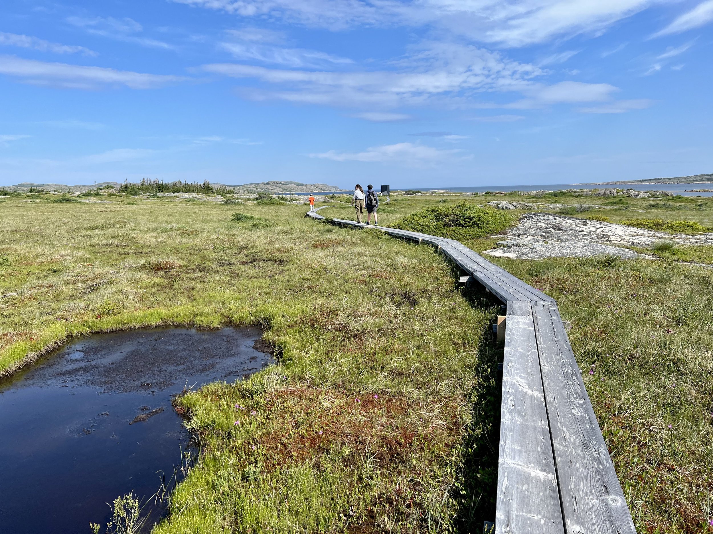


This isn’t a registered trail, but more of an easy stroll over a bog along a narrow boardwalk and then rocks. I include it because it’s short and because people often drive by without knowing they’re welcome to get a closer look at the last of the four eye-catching studios created for Fogo Island Arts. Just remember not to disturb the artists at work.
The three-storey Tower Studio, in the words of a map given to Fogo Island Inn guests, “provides a verticality that doesn’t otherwise exist on Fogo Island.” On my August visit, the weathered boardwalk was flanked by bog cotton, Labrador tea and pitcher plants — Newfoundland and Labrador’s carnivorous symbol.
Type: Out-and-back
Approximate Distance: 1.3 km
Trailhead: Look for the small parking area across from the studio on Route 334 between Central and Shoal Bay.
Insider Tip: On Herring Cove Road in Shoal Bay, pop into Fogo Island Metalworks to see Marc Fiset and Herring Cove Art Gallery and Studio to chat with Winston and Linda Osmond.

Jennifer Bain
After a career at daily newspapers, Jennifer began travelling the world in search of quirk in 2018. She goes wherever the story is, but has a soft spot for Canada and has been to all 10 provinces and all three territories. Jennifer has won multiple awards and written two cookbooks and three travel books. She lives in Toronto but has a vacation house on Fogo Island, Newfoundland, which some cheekily say is one of the four corners of the supposedly flat earth.